SAWA
Even if there's a line on the map,
It was not known which land adjacent to the stream.
The rivers are drawn on the map. The boundaries of the land are also available as data from the Ministry of Justice. However, we did not find a mechanism that could answer the question, "Is the stream connected to this location?"
SAWA is a combination of the two.Determine by geographical unit.This is an analytical system developed for the use in the field of physics. The information about the land that Sawa Bank publishes comes from here.
PRINCIPLE
The presumption, the reality, and the law.
Don 't mix these three.
This is the first decision in SAWA's design. It holds three types of information of different properties, separated by color, line type and score. Do not synthesize.
Estimation layer
Calculation from topographic data (DEM)
It is based on the calculation of the direction of water gathering from the elevation, and the drawing of a path that can be used as a channel. It's a mechanically requested "there seems to be a stream."It's not proof of water.
Current state layer
The water system of the Institute of Geography, the actual water area of the aerial laser, and the local photographs.
This is proof that there is actually water. But...It is not "none = no water." The aerial laser is not reflected back on the water surface, and it is easy to underestimate, and the fine stream under the canopy is not shown. It is treated only as confirmation of positive.
Layer of law
Rivers in the cadastral map and the national land data.
It is a waterway with an administrative and legal position. I don't know if the water is actually flowing. Water extraction and the suitability of the workpiece are involved here.
HOW IT WORKS
I don't know what you're doing.
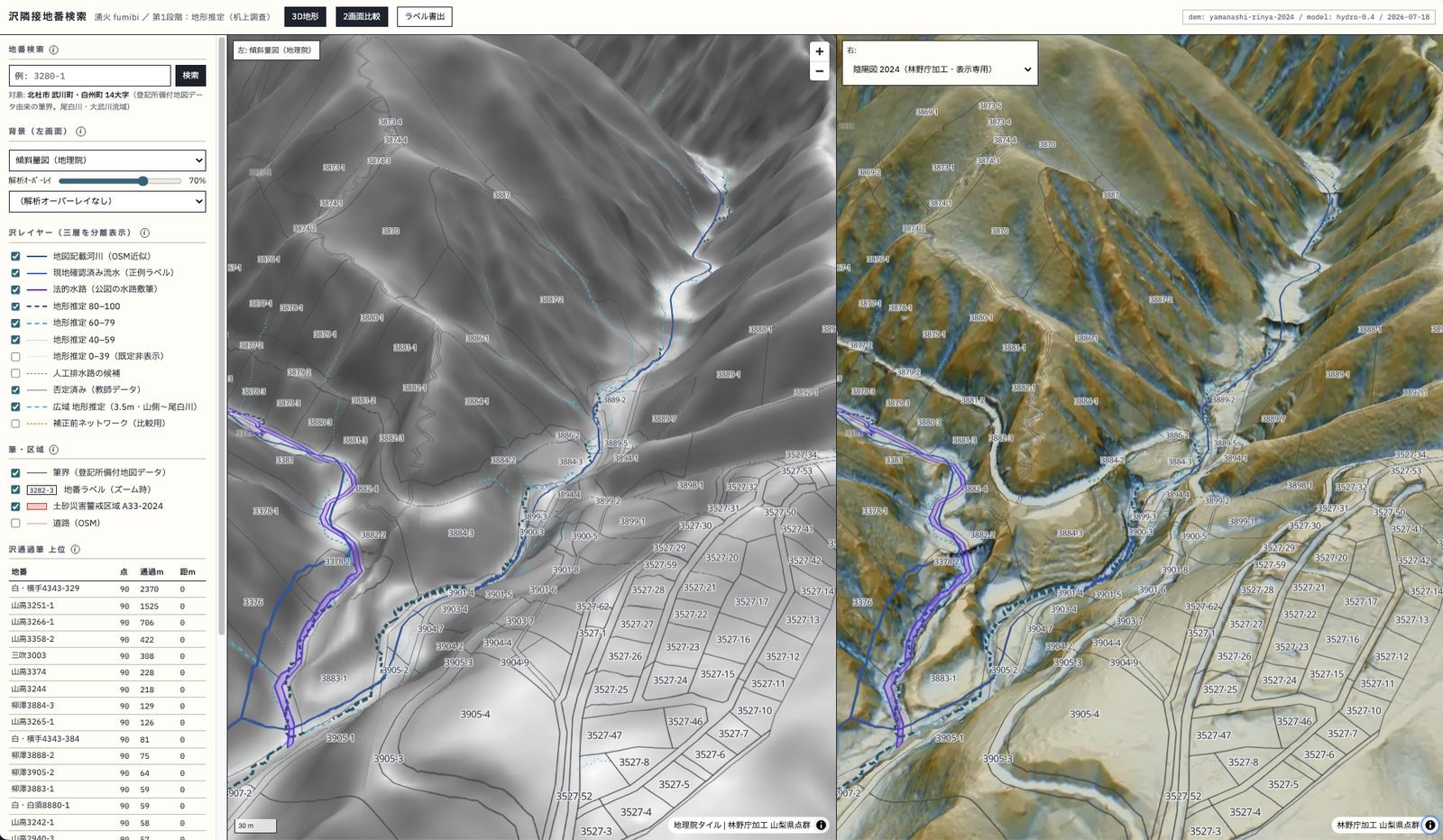
The method of estimating the flow path from the terrain is described.
The direction of water collection from the elevation is calculated using the 1m mesh DEM derived from the point group of Yamanashi Prefecture, which is published by the Forestry Agency, as the main source. In this paper, we present a method for the calculation of the flow rate of a river in the direction of its rapidest descent. The streams exceeding a certain catchment area (0.05km²) are extracted as streams and divided by confluence points.
Compare with known rivers and waterways.
Compare the rivers on the map with the watercourses on the cadastral map. It distinguishes which of the estimated arguments are supported. Unsubstantiated things are treated as estimates and not as real.
Overlapping with parcel boundary and dropping to geographical unit
This data is superimposed on the official cadastral map data of the Ministry of Justice to determine which land number the canal touches or passes through. How do you do it?It is divided into 3 types of contact: contact within the site, contact along the boundary, and contact only at the angle.It is mechanically determined by the ratio of the length passing through the interior to the total length. If you touch only the corners, you will be warned.
Quantify the condition
The relationship with stream, slope, flat land, road access, disaster area, building, farmland, and terrain classification. The area is calculated in the plane perpendicular coordinate system.This is the area on the map, and it is different from the registered land area.This is always noted.
I'm going to check the flow of water on the desk as much as I can.
Streams of 0.5 to 3m width flow under the canopy and are not visible in aerial photographs. But...There is always a bridge or a tunnel at the intersection of the roads. It extracts 12,217 intersections between streams and roads, and calculates the angle to the upstream side, so that a photo of the location can be verified.
I'll check on the spot.
So far, it's all on the desk.You can't know if the water is actually flowing until you go there. In this paper, we describe the method of determining the distance between two points on the surface of the earth.
SCORING
I don 't put the scores together.
The evaluation is carried out in four independent axes. The synthesized comprehensive points are not stored in the data, but the user can decide the weight and replace them.
- (1) Terrain estimation score.
- The ease of flow of the stream from the terrain is studied. 0 to 100 depending on catchment area
- (2) Evidence of the description.
- The amount of support as a description, such as the water system of the Geographical Institute and the waterway of the cadastral map.
- (3) Prospect of constant flow of water.
- The axis of the project is estimated from soil, vegetation and spring water observations, etc.Not implemented at the moment.
- Risks of desk screening.
- This paper presents a comprehensive analysis of the risks of earthquakes, floods, landslides, and protected forests.
The "SAWA score" given on the property page of Sawa Bank is an example of a combination of the weights of stream 30, flat 15, slope 15, width 15, rurality 15, low risk 5, and evidence 5. This weight is not absolute.
OUTPUT
Whatever you can get.
If you specify a target area, the following is calculated for all parcels in that area. Does not contain owner information.
Stream relationship
- Differentiation between crossing the site, along the boundary, and contact only at an angle
- The length (m) through the interior of the parcel and the length (m) that touches it
- Distance to stream, catchment area upstream
- The resolution of the mesh used for the determination (1m/3.5m/5m) is 1000×1000, 1500×1500, 2000×2000, and 3000×3000.
- The origin of the flow path (three layers: estimated, current, and legal)
Topography
- The median of the slope and the 1% value from the steeper one.
- The area of the compacted plain and its maximum section.
- Topography classification (ridge, valley bottom, fan-shaped terrain, etc.)
- Canopy height and openness ratio
- Thinness (detection of flagpole and striped ground)
Road access
- Distance to road and type of nearest road
- Width of measurement(Calculated from opposite pairs of road edges.)
- It's a 10-foot-wide road.
- Is it a road that can be used from the outside, or only the internal roads and private roads?
- It is adjacent to the roadside on the cadastral map.
Disasters and regulations
- flood inundation assumption zone
- debris flow hazardous stream, landslide, steep slope collapse hazardous area
- Large-scale earthquakes
- Designation of the water source area (area that requires submission prior to contract)
State of the land
- Area on the map (in square meters)
- Whether or not it is agricultural land, and the proportion of overlap.
- There is no building, number of buildings, area, coverage rate, and distance to the nearest building.
- parcel boundary
- Determination of exclusion of public land (waterway-side, road-side, no-land-page, and narrow-side)
Form
- CSV / GeoJSON / map images
- The coordinate system is WGS84, and the area and distance are the plane perpendicular coordinate system.
- From the same input,Always the same output. (no random numbers)
COVERAGE
Parsed range
- Hokuto Shi (北杜市)
- 69,785 parcels (Kazusu, Yokote, Hanamichi, Mibuki, Yasuzawa, etc.). 14 kanji (mainly in Takegawa-cho and Shikoku-cho)
- Nirasaki Shi (韮崎市)
- 18,057 parcels (Hanyama, Aoki, Shimo-en-Ii, etc.). North-West)
- Minami Arupusu Shi (南アルプス市)
- 27,721 parcels (over 400m altitude).Map display, road access, building, stream line. The stream score is the next step.
- Extensions
- This paper presents a method for using official cadastral map data and high-resolution topographic data in a region. I'll be happy to help you.
DATA SOURCES
What data is being used?
It's all public data. How to combine them and how to make a judgement is our job.
| parcel boundary | Ministry of Justice official cadastral map data (via G Space Information Center) |
|---|---|
| Topography | Forestry Agency Yamanashi Prefecture Point group derived from 1m mesh DEM. 10m‐scale DEM to compensate for wide area and missing measurements. |
| Real water department | The water data from the Yamanashi Prefecture point group (0.5m) is obtained. |
| Rivers and waterways | Ministry of Land, Infrastructure, Transport and Tourism. |
| Roads | GSI vector tiles (primary), OpenStreetMap (supplementary), and roads shown on cadastral maps |
| Buildings | Geospatial Information Authority of Japan Vector Tile |
| Agricultural land | Ministry of Agriculture, Forestry and Fisheries |
| Disasters | Ministry of Land, Infrastructure, Transport and Tourism National Land Numerical Information, Real Estate Information Library, Institute of Disaster Prevention Science and Technology |
| Background map | Geospatial Information Authority of Japan tile (aerial photographs, standard maps, gradient maps, etc.), Forestry Agency shadow map |
The terrain tiles are rebuilt by myself. When the common 10m class DEM is used as it is, the terrain is distorted so much that the flat field appears wavy. The measurements showed that the amount of detail information was about 1/3 of that of the Forestry Agency's 1m data, and there was a deviation of median 7m at altitude. In this paper, we propose a method for calculating the spatial distribution of the forestry data in the forests of the United States. He burns 4,345 tiles himself, changing the range for each zoom.
LIMITS
What you can't do, what you can't make.
I'll write it down first. If you use this without understanding it, you will make a wrong judgment.
I don't know if there's water.
It is just a "water-collecting muscle" that is drawn from the terrain.It is not possible to determine whether it is actually flowing or not all year round. It is not uncommon for streams to dry up during dry seasons. The system is designed with the prospect of constant flow as the third axis, but it is not implemented at present.
You can 't pick up invisible water.
Dark channels, pipe drainage, and streams completely covered by canopy do not appear in the topographic data. On the other hand, artificial grooves are sometimes picked up as streams. We've got real water data.It is useful only as a confirmation of positive.And, "Not in the data = no water" is not the case.
In a network of rivers, they 're offset.
In the section where the flow is divided into several streams in the fan‐like terrain, the calculated flow center may deviate from the actual flow path by about 100 to 300m, and at most 500m.There is no substantial solution except to increase the detail of the grid.
There's an error in the land that's been divided.
On land with branches, the neighboring brush is sometimes in between the stream. This is a part which is still easy to be misjudged.We will mark the parcels that may be concerned.
The parcel boundary depends on the accuracy of the registration data.
In areas where the cadastral survey has not been completed, the cadastral map will not match the actual location.Cannot be used for boundary determination. parcel boundary
The area is the one on the chart.
It's an area calculated from the shape on the map.This is different from the land area in the register.Cannot be used for the number of transactions.
Road access is a decision on the desk.
Just by looking at the connections with the road data,This is not a judgement of whether or not the road access obligation on the building standard law is fulfilled. The classification as a 'general road' does not mean that third parties can pass through it.
The flatness of the land depends on the roof and the pavement.
The roof of a building and the pavement surface are also included because the flat surface is taken as the terrain. The coverage rate of the building is also listed, so people should see it to judge. In the rough region of the resolution, the values of the flat area itself are used.Leave the field empty without calculating.You can't fill it with guesswork.
It 's a different story if you can use water.
The division under river law, customary water rights, and regulations of municipalities.SAWA is not able to judge whether water extraction is permissible. Can we use the water from the stream? Please see the following.
AVAILABILITY
The form of the offer
- It's a one-time thing.
- Please specify the target area and we will provide you with the analysis results at that time.
- Forms that keep updating
- I'll update you as soon as I get more information.
- Costs
- This varies depending on the width of the target range, the required metrics, and the frequency of updates. First of all, I'd like to ask you a question.
- I can't give you anything.
- Personal information of the owner obtained from the registration record. Transfer of the database itself
- Restrictions on use
- The usage of the source data will be subject to the terms and conditions of the source data provider. Please mention the source.
The region outside the analysis scope is discussed. Of the land listed in Sawa Bank, only the above range has been analyzed by Sawa. For properties in other regions, the relationship with the stream is arranged based on the information of the publishing source, and the parsing value is not displayed. This is a measure to prevent unsubstantiated numbers from being given.
CONTACT
Using SAWA
Please let me know the target area and what you want to judge. First, we will tell you about the range of analysis and the degree of accuracy. I'll tell you that I can't do what I can't.